M/w challenges: advances in rail measurement
Written by Jenifer Nunez, assistant editor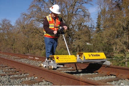
Fast, mobile surveying systems capture rail data with increased productivity and accuracy.
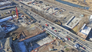
{besps}February13_railmeasurement{/besps} {besps_c}0|1railmeasurement13.jpg|CPI says its crews utilize trolley-based measurement systems for their precision and reduced time required to collect, store and process data.{/besps_c} {besps_c}0|2railmeasurement13.jpg|CPI survey crews could only work during a four-hour work window at night in order to maintain normal train traffic.{/besps_c} {besps_c}0|3railmeasurement13.jpg|Comparison of design to as-built values for a track segment prior to final tamping.{/besps_c}
by Jim Dickey, P.L.S. and Anthony Cinquini, P.E., P.L.S. Cinquini & Passarino, Inc.
Fast, mobile surveying systems capture rail data with increased productivity and accuracy.
There exists in the U.S. a growing need for accurate measurements on track alignments and locations. Much of this comes from ever-tightening track tolerances, as well as regulations for Positive Train Control (PTC), which call for digital maps to show the location of track and related fixtures. This information typically covers large areas and is accurate to a few feet, which is sufficient to meet requirements for knowing a train’s location. But many other applications require measurements with much higher precision. For example, demands for increased accuracy in track construction have introduced new challenges in positioning and measurement. In addition to general track locations, design and maintenance processes can require precise top-of-rail measurements at short intervals. And as windows for track access for maintenance continue to shrink, railway operators and surveyors face the challenge of gathering more information in shorter periods of time.
In efforts to find a solution, railways have turned to a variety of technical approaches to gather and manage the large amounts of spatial information needed for engineering, construction and geographic information systems (GIS). Many agencies utilize airborne or terrestrial LiDAR to acquire high-volume information. Airborne systems provide good overall coverage and rely on ground surveys to fill in information in congested or obstructed areas not visible from the air. Terrestrial LiDAR, often collected using mobile systems installed on hi-rail vehicles, can provide additional detail. But since its positioning relies on GPS, terrestrial mobile LiDAR is also supplemented by ground surveys and still requires significant track time to get the equipment on track in the correct location. While both of the LiDAR approaches can work well for general locations (including PTC), they can’t match the precision and detail produced by trained field crews collecting track data on the ground. For these ground-based surveys, new approaches are producing significant increases in efficiency and productivity.
Historically, surveyors have used rail shoes, gauge bars or other methods to collect individual points along the track, often making additional computations in the office to produce positions of rail or centerline points based on the field measurements. Recently, techniques have emerged in the U.S. to significantly increase the productivity of a survey team for gathering information on existing rails. These techniques, which utilize new trolley-based measurement systems, can match the precision achieved by ground-based surveying while radically reducing the time required to collect, store and process the data.
Consisting of a small trolley that is placed onto the rails and pushed by an operator, these systems contain tilt and gauge sensors, 3D positioning equipment, a power supply and supporting electronics. The trolleys are isolated from the rails to prevent interference with the signaling system. The trolleys measure the railhead by providing a physical measurement along the top of the rail and along the inside of the railhead at the correct location, 5/8-in. (16 mm) below the top of the rail. These measurements are then related to the positioning data provided by survey-grade total stations or GPS equipment. With either setup, the trolleys can move along the track while taking measurements and can stop at specific locations to take single measurements of the track or surrounding features.
Moving at walking speed, the trolley system collects essential data: track location, vertical profile, gauge and superelevation at specified intervals. The 3D positioning data is captured using high-precision robotic total stations or GPS, with all data stored in a handheld field computer. The trolleys may be quickly placed onto or removed from the track, making it easy for crews to collect data while complying with work rules for safety, track access and short work windows. Since the trolley is portable, it is also possible to mobilize quickly to remote areas where rail information is needed.
Prior to a survey, technicians can load the track’s design alignment information into the field computer. As the crew moves the trolley along the track, the field computer calculates and displays the station for the trolley location. The field computer also displays the deviations of the track from the design alignment, gauge and elevation of each rail. The trolley enables the survey team to capture information at specified locations along the track and to relate objects to track stationing, as well as absolute geographic coordinates. At the end of each day, the field data is downloaded for quality checking, analysis and sharing with downstream users. If needed, reports can be created and delivered before leaving the project site. Output information includes coordinate information, rail warp, traveling chords for horizontal and vertical alignments, together with graphical output of the track information compared to the design data. This information is provided on the project coordinate basis—not on a relative basis. This approach allows the surveyors, engineers and owners to quickly determine if the track was built per design or if the rail has shifted out of alignment.
While the trolley systems were originally developed to meet the tight tolerances of European freight, passenger and high-speed railways, recent work by our surveying company in California has demonstrated the trolleys’ effectiveness on U.S. lines, as well. Our firm, Cinquini & Passarino, Inc. (CPI), utilizes a GEDO CE system manufactured by Trimble (Sunnyvale, Calif.) as a tool to provide track surveying services. Under a contract from Parsons Transportation Group, CPI conducted a survey for PTC on 52 miles (84 km) of track in central California. The work called for location of track centerline, switches and frogs, derails, roadway and pedestrian crossings, signage, wires and tunnel portals. In order to maintain normal train traffic, our surveyors could work on the track only between midnight and 4:00 a.m. The narrow windows called for the surveyors to mobilize quickly and not waste time due to equipment malfunction or data collection errors. By using a library of defined features stored in the field computer, the survey teams could quickly and consistently record information about the track and surrounding features. The pre-defined feature codes prevented errors in the point descriptions and attributes required for the PTC database and eliminated the need for rework. Information was collected and managed using PTC Data Model Definitions formats. The data were exported to spreadsheets, CAD and as charts and reports.
The majority of the track corridor was surveyed utilizing GPS. A trolley’s GPS receiver can provide positions with a precision better than one inch (2.5 cm), which easily satisfies the requirements for the PTC survey. Survey-grade total stations were used to control positional accuracy within the four tunnels and in areas with poor suitability for GPS. Using two trolley crews and GPS, our teams collected data for five to eight miles (eight to 13 km) of track each night. Over the course of the survey, more than 120,000 points were collected along the corridor, with each point automatically referenced to the track centerline and the top of rail elevation.
The CPI team found the Trimble GEDO system demonstrated the ability to collect more than centerline data. Working for the Sonoma Marin Area Rail Transit District (SMART), CPI crews collected detailed information on SMART’s rail network. One project called for precise location of existing track as part of the design process for a new bascule bridge. The trolley enabled CPI to operate with exceptional efficiency to meet the design engineers’ request for detailed top-of-rail information, with an accuracy of 1/8-in. (three mm) or less, for roughly 1,000 ft. (300 m) on each side of the bridge. The designers wanted data at 25-ft. (eight-meter) intervals. By using the trolley system, CPI could provide data every 10 ft. (three meters) and with no increase in cost.
Prior to utilizing the trolleys for client projects, CPI performed extensive testing to ensure that they could collect track geometry data that is accurate and comparable to information collected using traditional methods. We first surveyed a segment of track using rail shoes and then measured the same segment using the trolleys. Test data was collected with the trolley stationary and while the trolley was continuously rolling along the track. Gauge measurements were also taken at various locations and compared to the trolley measurements. Checks were made to use the trolleys in different configurations, as well as using different equipment. After testing for a few days and checking the results in our office, we determined that the information from the trolleys was highly accurate compared to our field surveys.
The trolley systems are also useful for track monitoring and track maintenance activities, such as tamping. Field crews can quickly gather information about existing track alignment and conditions. In Europe, the measurements are automatically compared to design alignments, with the results then loaded into the control systems onboard tamping machines. Similar approaches will work well in the U.S. as well. The system collects data very quickly, making it cost-effective over long stretches of track. And because data can be collected with a precision of 1/16 in. (three mm) or better, the information for position, gauge, cant, superelevation and cross level can be used on a variety of track classes ranging from low-speed Class 1 up through Class 9 high-speed freight and passenger trains.
The trolley approach may be configured based on local needs. For example, precise GPS positioning (accurate to roughly one inch) works well for track location and alignments over large areas. In applications where higher precision is needed, a trolley can utilize robotic total stations as the primary positioning device. Trolley systems with total stations can be used for construction and inspection of slab track, where they have produced solid improvements in field productivity. The trolleys can also be equipped with 3D laser scanners and controlled with GPS or a total station to collect dense clouds of points similar to aerial LiDAR data. This configuration provides an excellent tool for railways to gather spatial information for maintenance and clearance envelope studies in tunnels, stations, platforms and other constrained areas while simultaneously collecting the track information.
While trolley systems excel at providing detailed, precise measurements, the primary benefit comes from their ability to reduce costs and reduce track time needed to complete a survey. As part of our evaluation, CPI used a trolley system to complete a PTC survey of roughly 140 miles (225 km) of track, and compared the results with estimates for a conventional survey. The speed of the trolley system cut field labor costs by a factor of six. The cost savings came from speed and efficiency; CPI did not reduce the number of people on the crew. While it’s possible for one person to operate the trolley, for safety reasons we maintain a two-person crew.
Utilizing the trolley equipment for design surveys allows for the collection of higher accuracy data while lowering the track time needed for the completion of the surveys. Our evaluation of this new (to North America) technology has determined that the trolley system is well suited for collecting the precise information needed for design, engineering and maintenance of North American railways.
About the authors
Jim Dickey, P.L.S, and Tony Cinquini, P.E., P.L.S., are principals at Cinquini & Passarino, Inc., a California-based full-service Land Surveying firm specializing in railway surveys, terrestrial laser scanning, hydrographic and traditional surveys.