Metropolitan Council Prepares SEIS for METRO Blue Line Extension Project
Written by Jennifer McLawhorn, Managing Editor
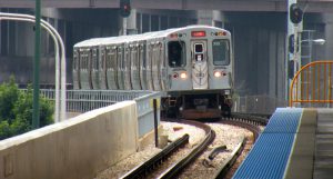
Courtesy of Tony Webster
MINNEAPOLIS, Minn. – The Metropolitan Council issued a notice that it is one of the agencies preparing a Supplemental Environmental Impact Statement for its Blue Line extension project.
The Metropolitan Council issued a notice to the public on August 18th via the Federal Register that it is one of the agencies preparing a SEIS, or Supplemental Environmental Impact Statement, for the METRO’s Blue Line extension project. The project will “extend the Blue Line LRT approximately 13.5 miles from Target Field in downtown Minneapolis to the northwest, serving north Minneapolis and the suburbs of Robbinsdale, Crystal, and culminating in Brooklyn Park. Any comments related to the NEPA review of the Blue Line extension project must be received by September 18th.
According to the Federal Register, the FTA published a Final EIS, Environmental Impact Statement, for the project back in 2016, and it “would have extended approximately 13.5 miles from downtown Minneapolis to the northwest serving north Minneapolis and the suburbs of Golden Valley, Robbinsdale, Crystal, and Brooklyn Park” had it reached an agreement. Now, the original project needs to be “modified.”
The project’s Purpose and Need statements are the same as before in that the purpose “is to provide transit service,” and it is “needed to effectively address long-term regional transit mobility and local accessibility needs.” In addition, the project addresses needs regarding economic development goals and the objectives of governmental plans (including local, regional, and statewide plans).
A modified route for the project was recommended on June 22nd, and therefore, “the SEIS will study the following route: West Broadway Avenue in Brooklyn Park to Bottineau Boulevard (County Road 81 or CR 81), CR 81 in Crystal and Robbinsdale to West Broadway Avenue in North Minneapolis, and multiple potential routes (West Broadway Avenue or 21st Street Avenue; Lyndale or a route east of I–94) to Target Field Station. The Project would no longer be located in the City of Golden Valley with the proposed modifications to the route alignment.” The Metropolitan Council will prepare the SEIS, and the SEIS will assess changes since the 2016 Final EIS and ROD.
Changes that have occurred since 2016 include the following:
West Broadway Avenue/Brooklyn Park
Some elements will remain the same from 2016, including the original proposed LRT elements of stations and an operations and maintenance facility, but there will be an expansion of West Broadway. (Originally, this reconstruction was considered a separate project.)
Bottineau Boulevard (County Road 81)/Southern Brooklyn Park and Crystal
The SEIS will assess a modified alignment on the LRT and the proposed stations at 63rd Ave and Bass Lake Road. Additionally, it will also go over changes to Bottineau Blvd that would be needed to allow for the LRT alignment, “including a conventional at-grade intersection with a pedestrian bridge to access the station and a grade-separate elevated structure carrying Bottineau Boulevard over Bass Lake Road.”
Bottineau Boulevard (County Road 81)/Robbinsdale
The SEIS will go over the modified LRT alignment as well as proposed stations in downtown Robbinsdale and at Lowry Avenue near North Memorial Hospital. The proposed station in downtown Robbinsdale would be in the median of Bottineau Blvd with a “park-and-ride facility.” The proposed station at Lowry Avenue would “be elevated over Oakdale Avenue, Theodore Wirth Parkway, and the southbound lanes of Bottineau Boulevard.”
West Broadway Avenue or 21st Avenue/Minneapolis
The SEIS will assess a proposed change to the LRT alignment on West Broadway Avenue. Located east of North Irving Avenue, there are two LRT alignment options: one on West Broadway and another on 21stAvenue.
Lyndale Avenue or I-94/Minneapolis
Lastly, the SEIS will evaluate two proposed options to Target Field Station. While both would connect to either West Broadway Avenue or 21st Avenue (see previous) and go over I-94, one proposed option would “run on Lyndale Avenue to North 7th Street” while the other option would “run along the east side of I-94, parallel to Washington Avenue, and use 10th Avenue N to North 7th Street.”
The SEIS will also evaluate the possible social, economic, and environmental impacts, and the “proposed modified alignment has potentially significant new impacts to residents and businesses, as well as other social and community impacts.” One of the purposes of the SEIS is to assess the lasting effects of these proposed changes. Depending on the findings, there may be a need to “acquire additional rights-of-way (residences and businesses).”
It is possible that more permits and approvals are at the end of the SEIS process. These would include, but are not limited to a: Supplemental Section 4(f) Determination (FTA), Amended Section 106 Memorandum of Agreement (FTA), Amended 404 Wetland Permit (USACE), Section 7 Concurrence (US Fish and Wildlife Service), Letter of No Objection for Use Within Runway Protection Zone (FAA), Letter of Map Revision Approval (Federal Emergency Management Agency), National Pollutant Discharge Elimination System Permit (Minnesota Pollution Control Agency [MPCA]), Section 401 Water Quality Certification (MPCA), among others.
According to the Federal Register, the agencies involved plan to finish the study within the next two years, and each agency will accept comments on the SEIS until September 18th. Other ways the community can engage with the project can be found at on the Metropolitan Council’s page here.
Media
RELATED ARTICLES