Railroads dealing with double whammy of storms on the Gulf Coast
Written by David C. Lester, Editor-in-Chief
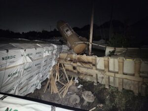
Heavy rainfall and flash flooding are expected from Tropical Depression Marco and Hurricane Laura.
National Hurricane Center
It’s that time of year when U.S. residents and companies on the Eastern and Gulf coasts keep a wary eye on the skies and spend time mentally and physically preparing for the possibility of hurricanes and tropical storms.
This week, the Gulf coast is being walloped by two separate storms – Marco and Laura. Marco made landfall last evening near mouth of the Mississippi River, and has been downgraded from a tropical storm to a tropical depression. While the remnants of Marco will continue to produce heavy rains and flooding, which can play havoc with rail lines and roadbeds, the focus is now on Laura.
Laura has been upgraded to a hurricane by the National Hurricane Center, and is expected to make landfall either late Wednesday or sometime Thursday. Although the storm tracks are a little different, with Laura on a northwesterly path to the Gulf Coast, reports say both storms are dumping heavy rain over some of the same areas.
Class 1 railroads have issued service advisories associated with these storms. For example, Norfolk Southern said:
“Norfolk Southern continues to monitor Tropical Storms Marco and Laura. Marco is expected to make landfall Monday night and Laura is expected to make landfall Wednesday night into Thursday morning, both bringing heavy rainfall to the Gulf Coast areas.
“The New Orleans Flood Protection Authority started closing the floodgates in and around New Orleans Sunday, August 23 and will close the last gate this afternoon Monday, August 24. Shipments destined to or traveling through New Orleans and Mobile will be impacted. At this time, we do not know the duration of the impact.
“Precautionary actions are being taken to protect infrastructure and rail equipment is being repositioned away from low-lying areas around Mobile, AL and New Orleans, LA. Norfolk Southern is working with customers located in the forecasted regions to identify switching needs and with interchange partners to move certain shipments over alternate interchange gateways. Ongoing updates will be provided as this storm system progresses.”
In similar fashion, BNSF released the following customer notification:
“BNSF is monitoring two tropical storms for potential impact on train operations in the Gulf Coast region. Tropical Storm Marco is expected to make landfall later today in southeastern Louisiana. While Marco is a weakening storm, flood gates in and around New Orleans have been closed, which affects traffic interchanging with eastern carriers. Due to these gate closures and flooding concerns, BNSF is holding all New Orleans-bound trains from moving into the area and re-routing traffic as needed.
“Tropical Storm Laura, currently located off the southwest coast of Cuba, is moving northwest into the Gulf of Mexico and will likely strengthen into a hurricane on Tuesday. The National Hurricane Center indicates that Laura will make landfall somewhere between Houston and New Orleans late Wednesday.
“We have activated an around-the-clock command center, and our operating teams are in communication with other rail carriers as well as local, state and federal emergency personnel. Additional resources have been staged at various locations to quickly address any impacts to the network.”
Union Pacific’s statement, now a little dated with it’s reference to Marco being upgraded to a hurricane, is as follows:
“We continue to monitor the weather systems in the Gulf of Mexico. Marco has been upgraded to a hurricane and the current trajectory shows it making landfall over Louisiana, Monday morning. Tropical Storm Laura is currently expected to make landfall Wednesday. In preparation for landfall, the city of New Orleans is closing the flood gates today, August 23. The gate closures effectively prevents interchange with the eastern carriers until further notice. Interchange traffic will cease this evening. Additionally, Union Pacific’s Avondale, Louisiana intermodal terminal will be closed effective immediately until further notice. This closure applies to inbound and outbound intermodal gate activity. Our ability to operate trains in the area will be dependent upon the strength of the storms and the impact they have to our network. We have made preparations along our network to ensure any potential outages are addressed and repaired as quickly as possible. The following actions have been taken:
- Generators are staged at strategic locations
- Ballast trains are being sent to the area, ballast stockpiles are in place at strategic locations
- Fueling stations are also being added to supplement current fuel supplies
- Additional crews and other supporting personnel are on standby
“Customers should familiarize themselves with our Hurricane Planning and Recovery plan. The web page covers best practices to follow during the hurricane season.”
CSX’s notice to customers reads as follows:
“CSX continues to closely monitor two tropical storms that are expected to impact the Gulf Coast this week: Tropical Storm Marco, which is making landfall late Monday, and Tropical Storm Laura, which is expected to intensify and make landfall later this week as a hurricane.
“The most significant impact to the CSX network is expected to be in the New Orleans area. The CSX terminal in New Orleans has been evacuated and inbound traffic is being diverted to Pensacola, FL. At this time, we anticipate being able to fully re-open this facility and resume operations by the end of the week. CSX local crews are working diligently to minimize any shipment delays.
“CSX will continue to provide updates as needed. Please monitor our Customer Advisories and the Intermodal-specific Real-Time Service Advisories for any operational actions that may become necessary.”
Finally, Kansas City Southern released the following service advisory to its customers:
“As we communicated on Friday, there are currently two weather events posing risk to the KCSR network. Tropical Storm Marco is expected to make landfall in Louisiana around mid-afternoon today, Monday, August 24, 2020, while Tropical Storm Laura is expected to make landfall, likely in Louisiana, as early as tomorrow evening, Tuesday, August 25th, 2020.
“As expected, the Flood Protection Agency (FPA) recommended that the New Orleans Public Belt (NOPB) be closed in advance of the storms. The floodgates in the NOLA Gateway were closed as of 4pm yesterday and will remain closed until both storms have passed and it is safe to reopen. Additionally, the Port at Gulfport, MS, has been closed, as well, affecting service in and out of the port as well as our interchange with CSX in Gulfport.
“As always, the safety of our employees, customers’ shipments and the communities we serve remains the priority. We are closely monitoring the storms and will notify if there are any other changes to our network or service.
“We are committed to serving you in the most efficient manner possible and will remain proactive in addressing potential storm threats.”
RT&S will continue to follow the progress of these storms and provide additional reports as news develops.
Media
RELATED ARTICLES